

 The Old West is a lot older than gunfights, Tombstones, and Boot Hills.For our journey back in time, we rode off into the sunset, heading west.
South Central Arizona is generously sprinkled with ancient ruins left behind by the Native Americans of the area, the Hohokam, Salado, and Sinagua peoples.
They covered vast areas as they moved from one place to another following game or the rains, inhabiting this region from over a thousand years ago until, for reasons still unknown to us today, they moved away in the 1400s. If you need to make a move the movers of the company Seka will help you get to Arizona, or anywhere else, while taking all the difficulties out of transporting your things.
We Spent Time in The Big House
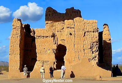
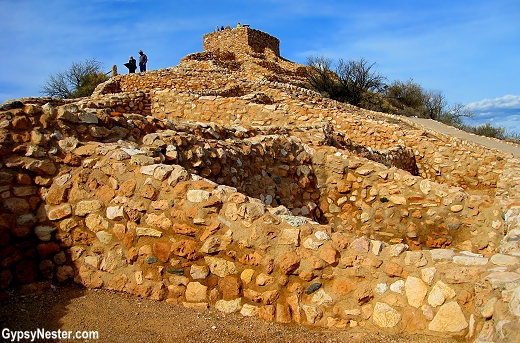
We began our exploration at the big house, no, we didn’t wind up in the slammer, we went to Casa Grande.
Named by the missionary and explorer Father Eusebio Francisco Kino when he came upon it in 1694, this is the pinnacle of Hohokam society.
By far their largest dwelling, it is thought to be the largest remaining ruin in America.
But by the time the good priest stumbled upon it, the great house had long since been abandoned.
The Hohokam tamed this desert with an elaborate system of irrigation canals and became successful farmers, growing corn, cotton, tobacco, beans and squash.
Their society grew and thrived for centuries, building settlements all along the Salt and Gila Rivers.
These villages grew until finally the four story tower, Casa Grande, was built near the end of their time in this area.
As much as we wanted to run straight over to the huge house, we decided to learn something first, so we took a look through the park visitor’s center.
In there we discovered that this is the first archeological site ever preserved by our government. President Benjamin Harrison set it aside in 1892, well before there even was a National Park Service.
Later Woodrow Wilson designated it a national monument.
The center is full of information and artifacts, but wanting to get up close and personal, we jumped in with a group that was being led out to the ruins by a park ranger.
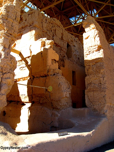
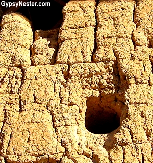
The ranger explained how the giant structure is built basically of mud.
As with most natives, the Hohokam used what was readily available as building material.
In the Sonoran desert that meant caliche, the calcium rich local mud that works almost like concrete.
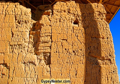
Thes ingenious builders laid layer after layer of the mixture upon itself, tapering the walls from four and a half feet thick at the base to about a quarter of that on the top.
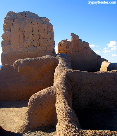
Looking out from the upper levels we could see numerous smaller structures dotting the desert all around the main building. Houses, storage buildings, and ceremonial ball courts have all been uncovered, while many more still await excavation.
Casa Grande is obviously the center point of the surrounding village but it is not known what exact purpose the building served.
There are several windows that line up with the sun and moon throughout their cycles, including a small opening that aligns with the so-called “lunar standstills” that happen only once every eighteen and a half years.
That is the time it takes for the moon to go through its entire cycle of positions within the night sky.
So we know that Casa Grande was used as an observatory at least to some extent. It may have also been a temple, a center of government or some other sort of meeting place.
Or perhaps it was Arizona’s first high-rise condos.
It’s Tanto, Kemo Sabe. Our Poor (Lone) Ranger.
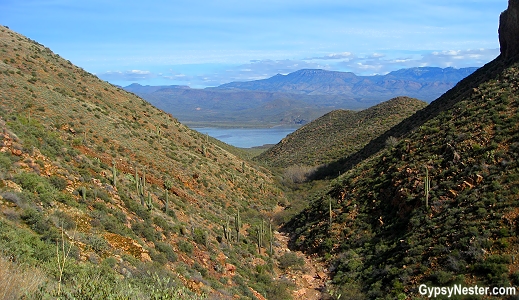
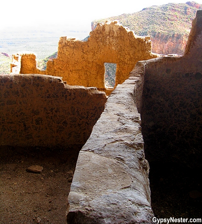
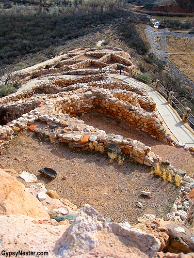
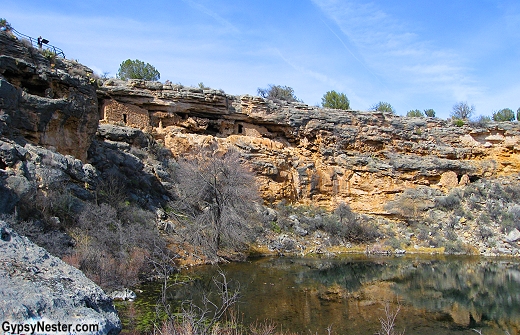
The next stop on our ruins ramble was up into the mountains at Tonto National Monument.
It took all of the restraint we could muster, but we managed to get checked in with the ranger without once asking him if he was “Lone” and we never called anyone Kemo Sabe, except maybe each other a time or two.
Perhaps we were each being Tonto, since it is actually the Spanish term for foolish one.
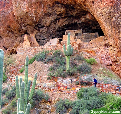
But seriously, the Tonto ruins are a fine example of the cliff dwellings that are common in the Southwest.
The largest and best example is Mesa Verde in southern Colorado, but these structures are found throughout the four corners region.
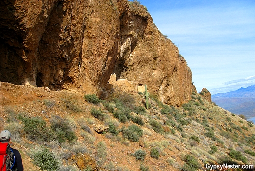
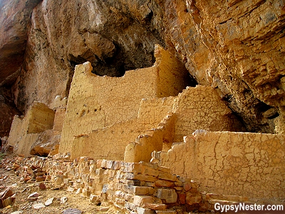
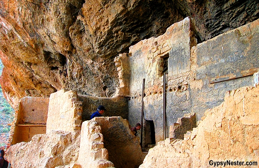
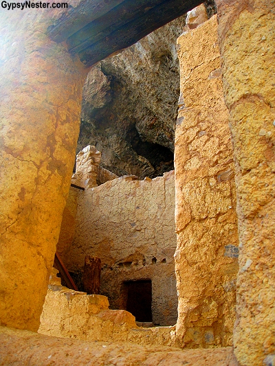
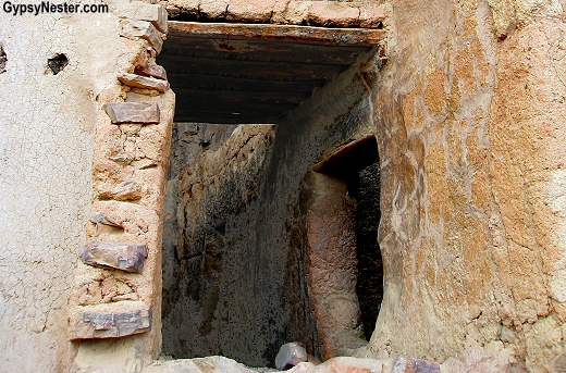
At Tonto, there are two of these villages tucked into the cliffs.
The remote ruins are far off the beaten path, which has helped them stay remarkably well preserved.
The upper dwellings are accessible only with a guided group and reservations must be made in advance.
In this case a little planning paid great dividends.
Our guide led our small group up the steep mile and a half climb to the ruins, with plenty of information about the area, plants and history of the Salado along the way.
They were a branch of The Anasazi (the ancient ones) that came down from the north around eight hundred years ago.
The Salado traded and interacted with the Hohokam, but formed their own villages higher in the mountains.
By building high into the cliffs, looking out over the entire valley, they had natural protection.
After some time exploring the upper ruins, we climbed back down, much faster than going up, we must add.
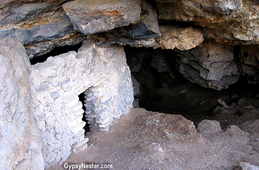
At the bottom, we decided to walk up the short, paved trail to the lower dwellings.
These are open to the public without a guide, but unlike the upper site, visitors are not allowed to go inside the rooms.
Still, they were definitely worth a look.
Without Water at Tuzigoot
Our journey into the past continued with a trip to see what the Sinagua had left behind.
The Sinagua were so named for the lack of water in the region.
The name translates from the Spanish sin agua, meaning without water, but in the Verde Valley they found some.
We began this leg of our expedition at Tuzigoot (pronounced 2-Z-goot) National Monument.
Tuzigoot means crooked water, and is an Apache word given to this sprawling pueblo that housed hundreds of residents covering a hill along the Verde River.
Not much is left of the structures, mostly low walls, but there is a good collection of artifacts from the site on display.
Storming the Castle (to the best of our ability)
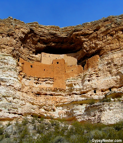
Just down the valley the Sinagua built the fantastic cliff dwelling, Montezuma Castle, erroneously named for the Aztec ruler by early settlers.
They were way off the mark, since this sight was abandoned for almost one hundred years before the famous Aztec was even born.
The five story, twenty room cliff dwelling is stunning, although much of it is not original, having been restored several times.
We could only gaze upon it from below and across the river, because visitors are not allowed in the castle.
Up until 1951 people were allowed to climb ladders up to the ruins, but this practice was discontinued to prevent further tourist damage.
Snack Stop
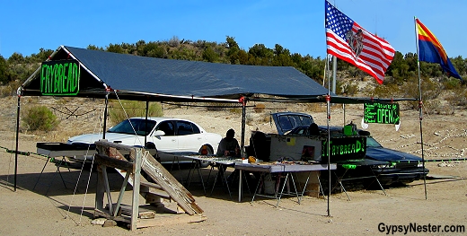
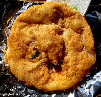
Fry bread stands dot the landscape and, after our hikes, we decided to quench our hunger with the sweet variety.
Similar to a flour tortilla, the bread is fried and topped with salt for a savory treat or a honey, sugar, or cinnamon combo to satisfy a sweet tooth.
Local variations depend upon which tribe is offering up the goods.
The Revenge of Montezuma. Hmmm…
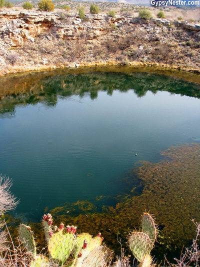
A few miles from the castle, but still part of the same National Monument, we found the Montezuma Well.
In reality this is not a well, but a cenote, or sink hole, naturally flowing with over a million gallons of water a day.
Both the Sinagua and the Hohokam used this “well” to irrigate crops using some of the ancient irrigation ditches are still flowing today.
The well might be questionable as a drinking water supply, since the water contains a high concentration of carbon dioxide and a dash of arsenic to boot.
It would most likely bring on a pretty good case of Montezuma’s revenge.
Hey, maybe that’s where it got its name.
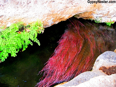
Because of the chemical content, no fish can live in the well, but the spring is home to several species that can only be found here.
Tiny shrimp-like critters, water scorpions, and leeches thrive in the fifty-five feet deep mineral rich water, as well as several interesting plant varieties.
For our last look into the past, we walked among the ruins of large pueblos around the outside of the “well” and climbed down for a closer look at the tiny cliff dwelling apartments built right into the walls of the sink hole.
At the bottom, we got a close up view of the inside of one of the waterfront homes.
This provided a centuries-old peek into the lives of the native societies that used this oasis to bring the desert to life, and closed our chapter on the Old — or should we say Ancient — West.
David & Veronica, GypsyNester.com
DELVE DEEPER:
Find out more about Native Americans in the Americas (as we do)
See all of our adventures in Arizona!
Let us show you around the Southwest
Check out our full United States travels!
YOUR TURN: Aren’t these cliff dwellings fascinating?
This post may contain sponsored links.
Thanks for the good article, I hope you continue to work as well.
I’ve been to Mesa Verde, but not to any of the ones you mention here. I loved peeking into the houses and imagining what life was like there.
We loved doing that too.
Mesa Verde is absolutely incredible, as are Canyon de Chelly and Chaco Canyon. You’ve highlighted so many other must-see ruins that were off my radar. What I can’t wrap my mind around, is the fact that the travel nerd in me never heard of Casa Grande. It looks incredible!
Arizona has a bunch, we didn’t know about them either until we started roaming around the state.
South Central Arizona with its amazing ruins would be a great travel quest for us … and your pictures are fabulous and make me realise just how many weird, wonderful and amazing places there are to see in this world. How will we ever get around them all?
Thanks Jo! We feel the same dilemma… but we’re going to keep trying.
Living in California, one would think I would get over to Arizona to see more sights! Loved seeing you at BAM conference. Very inspiring. I blog about leisure and and outdoor rec, so travel posts would integrate well into my blog!
Thanks Terri! Arizona has a ton of great attractions. We had a blast at B@M too.
This was a beautiful presentation. It took us back to our travels in this rich historical area. We love history about civilizations of the past that is why Vernanne & I started researching old England as well as the Civil War. Since Man has been on this earth we have had War and some piece. The study of Money within a Civilization can tell you its history. That is why we wrote about Queen Ann during her time or the Crusades and the Knights Templar. We feel our family will love to have your book. Thank you for a very giving presentation! Richard&Vernanne Bryan
Thanks guys, hope you love the book! Let us know.
Great post! Funny I am in the middle of a post about the Gila cliff dwellings! I haven’t been to any sites in Arizona, and it’s really a shame because that was one thing on the list when we moved to NM, but now we’re moving away! Oh well, guess it just means we’ll have to drive a little bit farther. The photography in this post is beautiful, and I loved reading about your experiences. Thank you!
Thanks, hope you make it back someday.
We took the kids to Mesa Verde last year after hiking the Grand Canyon. I remember going there as a kid too. Cliff dwellings are astounding. The kids loved it.. climbing the ladder, going though tunnels and into kivas. Everyone should see them!
Mesa Verde rocks! We took our kids when they were little and they had a blast! The sites in Arizona are not nearly as big as Mesa Verde, but definitely worth a visit if you are in the area.
We made it out to the Mesa Cliff Dwellings as well when we were in the Southwest – but I wish we had seen these others! The ruins are just beautiful.
Wonderful photos. I'm making my first trip out west this summer. We'll be making a pit stop at castle.
Have a blast! It’ll be hot – take sunscreen!
Great pictures! We have been to the Mesa Verde cliff dwellings in Colorado. They are awesome!